

22 Sep
- Golden State Digital Exchange
- Comment 0
What Is a Topographical Survey? A Definitive Guide for Your California Project
In every successful building, grading or environmental restoration effort, the first essential step is to understand the land itself. That begins with asking: what is a topographical survey? Also called a topographic survey or topography survey, this is a specialized type of land survey that captures both the shape and features of a site. In this guide we will explain how topographic surveys provide accurate data for construction project planning, architectural projects, environmental restoration, or civil engineering tasks. We will also show how Golden State Digital Exchange (GSDE) helps clients across California get reliable topographic survey data they can trust.
Introduction to Topographical Survey
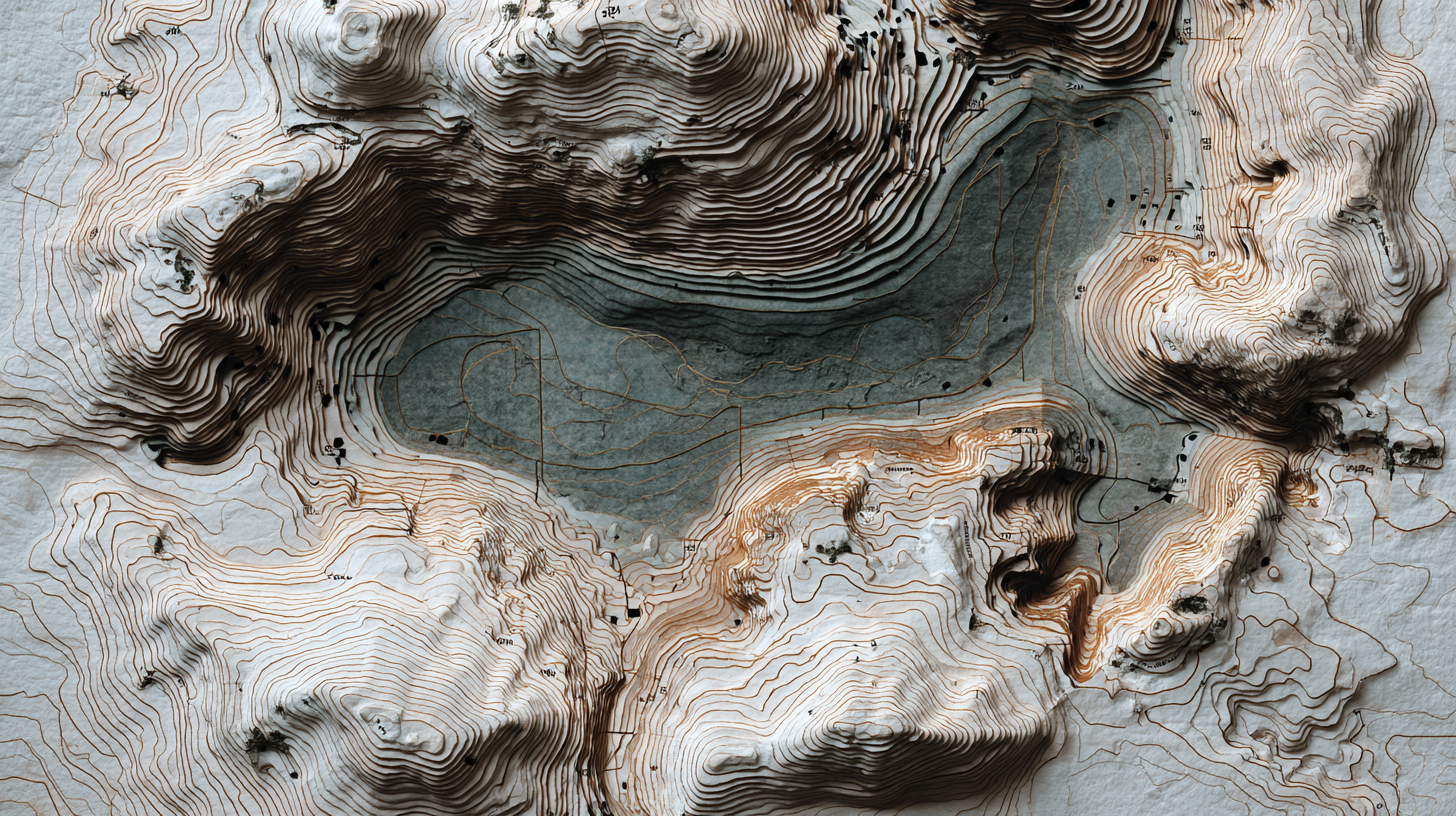
A topographical survey, or topo survey, is a detailed measurement of a property’s land’s surface, capturing both natural features and man made features along with elevation changes. In contrast to a boundary survey, which defines property lines and legal limits, a topographical survey focuses on how the terrain varies in three dimensions and what exists on it. The result is a map or model that shows everything from hills, slopes, trees, streams, to buildings, walls, driveways, and utilities.
While boundary survey data is critical for legal boundaries, a topographic survey gives designers, engineers, and planners the context they need: contour lines and elevation detail, so that you can determine how to place foundations, drainage, cuts and fills, grading, or even environmental restoration zones. In short, topographic surveys provide the context and accurate data essential for informed decisions in construction, architecture, and land use.
Topographic surveys differ from traditional maps that only show plan view features. They go further by layering in contour lines, spot elevations, and sometimes 3D models. Those maps and data are vital for geographic planning, urban planning, or any project that must respond to real terrain.
Key Elements Captured in a Topographic Survey

To understand what is a topographical survey, it helps to know the key elements that are typically included in a topographical survey deliverable:
- Contour lines, lines that connect equal elevation points across the parcel, used to visualize slope and relief
- Spot elevations or elevation points at specific locations across the site
- Natural features such as trees, creeks, drainage, ground surface textures
- Man made features like buildings, roads, walls, fences, utilities, retaining walls
- Existing features including those above and partly buried, if identifiable
- Site boundaries and property lines (if the survey is combined with boundary data)
- Horizontal angles and distances between points to accurately fix positions
- Topographic data tied to a datum (a reference elevation or coordinate system)
These combined elements allow you to see not just where things are, but how they relate in elevation. Designers and engineers use this data to model terrain, plan grading, and design foundation systems or drainage.
In effect, topographic surveys provide detailed information about the earth’s surface, enabling your team to build intelligently.
Why You Need a Topographic Survey
Skipping a topo survey may seem like a cost saving, but in practice it’s a risky move. Here’s when a topographical survey becomes critical:
For Residential and Custom Homes / ADUs
If you are building a custom home or accessory dwelling unit, especially on sloped or uneven terrain, topographic data is foundational. Without it, your architects and engineers guess elevations, slopes, or drainage paths, and that leads to misalignments, costly rework, or change orders.
For Construction Projects & Site Planning
Any construction project that involves earthwork, grading, cut and fill, retaining walls, or changes to drainage must rely on topographic survey data. The contours, elevation changes, and terrain model allow your civil team to balance cuts and fills, optimize material usage, and anticipate issues before the contractor arrives.
For Civil Engineering, Infrastructure & Permitting
Many regulatory requirements (city, county, or state) demand topographic maps or topo survey models for stormwater, grading permits, flood analysis, and environmental review. Without accurate data, permit applications may be rejected or delayed.
For Environmental Restoration & Sensitive Sites
In cases of ecological restoration, wetlands mitigation, or erosion control, topographic surveys provide the baseline terrain. You can then model water movement, erosion potential, or habitat zones. For architectural projects environmental restoration initiatives, combining building design with land restoration depends on accurate terrain context.
To Support Urban Planning & Land Use Decisions
For master planning, subdivision, or urban planning, topographic surveys allow planners to overlay infrastructure, roads, utilities, and open spaces while reacting to the natural terrain.
In all these scenarios, topographic surveys provide indispensable insight.
How the Survey Process Is Conducted
Understanding the survey process is critical because it defines how data collection happens, how accurate your topographic survey data will be, and how usable the deliverables are.
Step 1: Pre‑Survey Planning
Surveyors begin by reviewing existing maps, boundary data, and historical sources. The goal is to define the project scope, decide what features must be captured, and plan control points or benchmarks. Sometimes previous topographic maps or GIS sources are consulted.
Step 2: Setting Control & Reference Datum
To measure elevation, the survey team establishes control points and ties into known benchmarks or geodetic control. This ensures all data collected is consistent and can integrate with design documents.
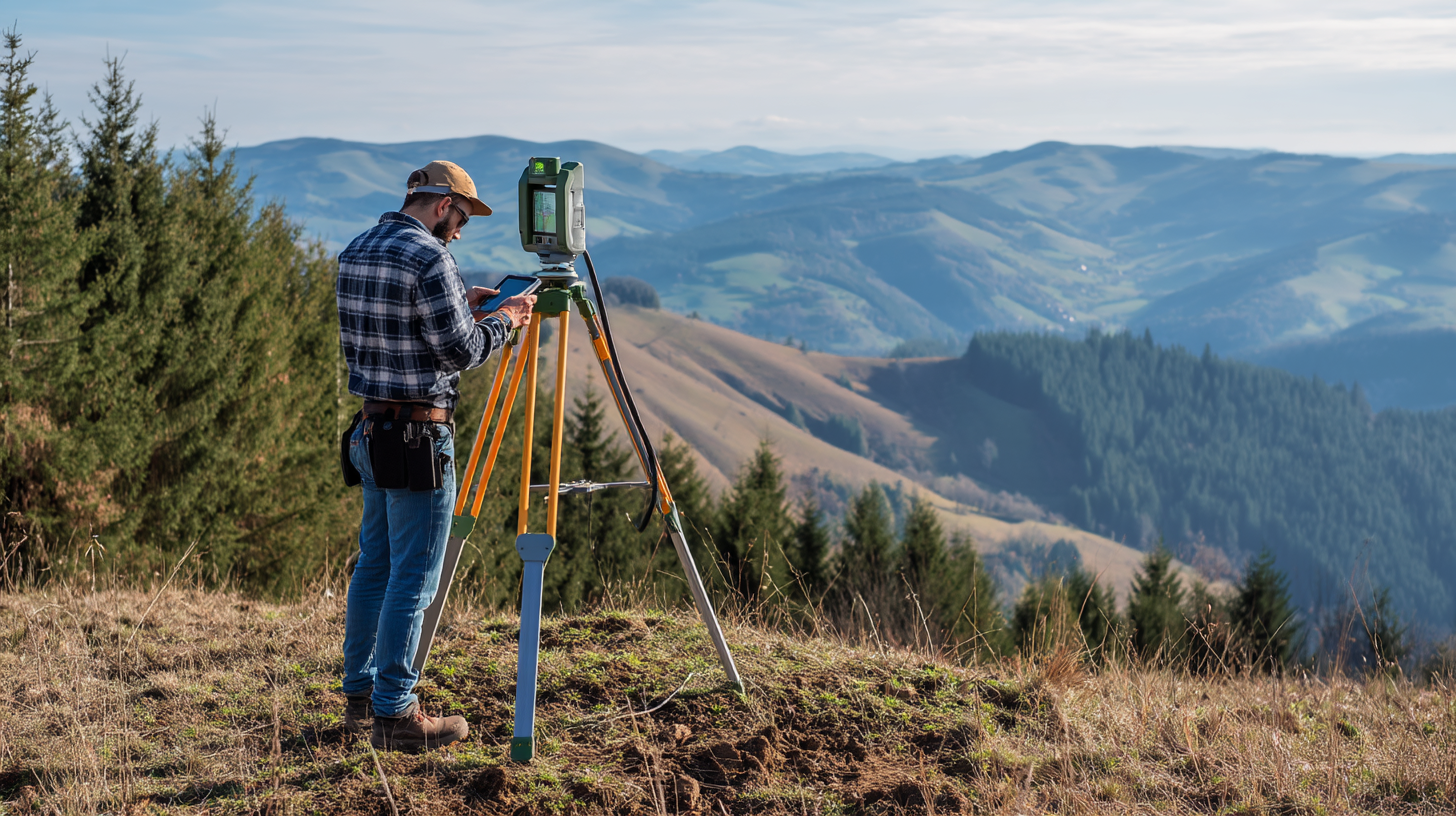
Step 3: Field Data Collection
This is where the crew visits the site and begins capturing coordinates, elevations, and feature locations. Common tools include:
- Total station or total station theodolite devices that measure angles and distances
- Electronic distance measurement (EDM) instruments
- Laser scanners or LiDAR systems
- GPS / GNSS receivers for georeferenced positions
- Drone photogrammetry or aerial imaging in combination
Surveyors measure horizontal angles, slopes, distances, and take notes on natural and man made elements. They record various points across the site, including corners, high spots, low spots, breaks in slope, and features.
Step 4: Data Processing and Modeling
Once the field data is collected, the team cleans, filters, and processes it. Redundant measurements are checked, errors corrected, and the data is tied to the control network. From there, they build a digital terrain model (DTM) or triangulated irregular network (TIN). Contour lines and spot elevation maps are derived.
Step 5: Deliverables & Review
The final output often includes topographic maps, CAD files (DWG, DXF), PDF plans, and sometimes 3D models. The maps show contours, elevation labeling, and mapped features. Engineers, architects, and planners then use the deliverables to integrate into site design, foundation layout, grading plans, drainage systems, etc.
This is how a topographical survey is conducted in modern practice.
Types of Topographic Surveys & Technologies
There are several types and approaches to topographic surveys, depending on site conditions, budget, and required detail.
- Traditional ground survey using total station, theodolite, and EDM: reliable in open terrain and small parcels.
- LiDAR / laser scanners: high density terrain capture, works well under foliage or complex terrain.
- Drone photogrammetry: for larger or less accessible areas, often combined with ground control points to improve accuracy.
- Hybrid approach: combining ground survey, LiDAR, drones, and GNSS to maximize detail and reliability.
Each method has trade‑offs in cost, speed, and accuracy. GSDE evaluates which combination ensures the best topographic survey data for your project.
Deliverables You Receive & How They’re Used
When you hire a surveyor, you’ll receive a package of deliverables built around the following:
- Topographic maps showing contours, spot elevations, and existing features
- Contour lines labeled with elevation, typically at regular intervals (e.g. 1 ft, 2 ft)
- CAD files (DWG, DXF) for your design and engineering teams
- Digital models such as a DTM or TIN model
- Profiles, cross‑sections if needed
- PDF or printed plans suitable for permit submittals
Your architects and civil engineering team will overlay building footprints, grading, foundation, drainage, and utility design based on this data.
Because topographic surveys provide the structure of the land, each deliverable becomes the foundation on which informed decisions are made.
Benefits of Having Accurate Topographic Survey Data
When a survey is done well and yields accurate data, the benefits to your project are significant:
- Improved design: architects and engineers can design in real context rather than guesswork
- Minimized risk: fewer surprises in the field when construction begins
- Efficient grading & earthwork: accurate cut/fill balancing, less waste
- Better drainage and erosion control: water paths modeled correctly
- Regulatory compliance: permit documents meet requirements for regulatory requirements
- Faster approvals: agencies often reject permit sets with inconsistent or low‑quality topo maps
In short, investing in a topo survey upfront saves time, money, and stress downstream.
Challenges & Considerations

Even with modern tools, topographical surveyors face challenges:
- Dense vegetation or tree cover can block line-of-sight
- Steep terrain or inaccessible zones complicate data collection
- Outdated benchmarks or missing control make datum alignment harder
- Conflicts with property lines or boundary data may arise
- Weather conditions or daylight limits
- Noise and artifact in point clouds need careful processing
GSDE mitigates these by doing hybrid data collection, planning around difficult zones, validating control, and delivering QA‑checked data.
Topographic Survey vs Boundary Survey
One common confusion is between topographic survey and boundary survey. A boundary survey focuses exclusively on defining property lines, ownership corners, and legal monuments. It’s crucial for land title, ownership, and legal compliance. Meanwhile, a topographical survey maps the terrain, features, and elevation across the parcel.
Often both types of survey are combined: boundary data is overlayed on topographic maps so that you see how terrain relates to property lines. In projects such as subdivisions or construction projects, you will almost always need both.
Why Choose GSDE for Your Topographic Survey
At Golden State Digital Exchange, we pride ourselves on serving clients across Northern California with high reliability and integrated design support. Here’s why you should trust us with your topographical survey:
- Local experience working with Sacramento, El Dorado Hills, Santa Rosa, San Jose and their jurisdictional requirements
- We use the best combination of total station, GPS, laser scanners, drone mapping, and hybrid methods to produce topographic maps you can trust
- Our surveyors, civil engineers, and architects work together so you get clear, usable models and plans
- We ensure accuracy and quality control so you are ready for design and permitting
- Efficient turnaround and responsive client support
Whether your project is a custom home, ADU on a slope, subdivision, or environmental restoration site, GSDE tailors our data collection and mapping to your needs to empower accurate design decisions.
FAQs About Topographical Surveys
How much does a topographical survey cost in California?
Costs vary by parcel size, terrain complexity, and required detail. A typical residential lot topo survey can run several thousand dollars. Steep, large, or heavily fenced parcels cost more.
How long does a topo survey take?
A standard lot might require 1–3 days for field data collection, plus 2–5 business days of processing, modeling, and deliverable preparation. More complex sites take longer.
Is a topographic survey required for building permits?
In many jurisdictions permits require topographic maps or topographic survey data especially for grading, drainage, hillside construction, or environmental review.
What’s the difference between a topo and boundary survey?
A topo survey captures terrain and features; a boundary survey defines property limits. For most construction projects, both are needed.
Can drones or LiDAR replace traditional survey tools?
While laser scanners and drones are powerful, they usually augment rather than fully replace classical tools. Ground truthing, control points, and redundancy ensure accuracy.
How to Get Started
- Contact us and share your site location, size, and any existing maps
- We’ll scope the topographic survey requirements, terrain, site access, and deliverables
- We schedule a field run and data collection
- After processing and QA, we deliver your topographic survey data package including topographic maps, CAD files, and models
- Your architect and civil team begin design with confidence
Don’t let unknown terrain derail your project. Let GSDE deliver reliable topographic mapping so you build on solid ground.